|

Computerized Mapping Advantage
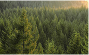
The benefits derived from computerized mapping can be applied to fields as diverse as geology, municipal planning, tourism, wildlife studies, in addition to forestry, with the help of Kestrel’s qualified professionals.
Our company has developed considerable skill in creating maps in arcplot and ArcView to suit various requests. Our familiarity with forestry data and operations enables us to work with forest managers on ad hoc requests to ensure that the appropriate data is used and the desired results are achieved.
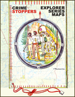
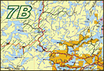
Improving Public Map Development
Kestrel has worked with Crime Stoppers to develop a quality recreational map product for most of northwestern Ontario. The Explorer Series project involved base data contributions from the Ontario Government and road updates from the Forest Industry. Combining data from a variety of sources has resulted in a quality product that will be very useful to a wide audience.
|